Budget Stay Starting @ ₹500 to ₹1000 in Jabalpur
What Are the Major Geographical Features of Madhya Pradesh?
Madhya Pradesh, often called the “Heart of India,” is located at the centre of the country, lying between 21°6’N to 26°30’N latitude and 74°9’E to 82°48’E longitude. The area of Madhya Pradesh spans 308,252 sq. km, making it the second-largest state in India. Bhopal serves as the state capital, while Indore, Jabalpur, and Gwalior are its other major cities. (The politics of Madhya Pradesh is covered in a separate blog.)
The state shares boundaries and geographical features with Uttar Pradesh to the north, Chhattisgarh to the east, Maharashtra to the south, Gujarat to the west, and Rajasthan to the northwest. The geographical division of Madhya Pradesh is broadly classified into three distinct regions:
- Central Highlands – covering the northwestern part, known for plateaus and rugged terrain.
- Satpura and Maikal Ranges – the forested, hilly region in the central and southern belt.
- Eastern or Baghelkhand Plateau Region – a plateau-rich zone with river valleys and mineral resources.
This division highlights the state’s diverse landscapes, ranging from mountain ranges to fertile river basins.
The Different Regions of Madhya Pradesh: From Plateaus to Plains

Let’s dive into understanding the different regions of Madhya Pradesh and their major divisions. The state is divided into five key geographical regions Bundelkhand, Baghelkhand, Malwa, Vindhya, and Nimar. Some of these regions of Madhya Pradesh extend into neighbouring states, sharing cultural and geographical similarities. Each region is distinct in its landscape while Bundelkhand and Baghelkhand are largely plateau areas, Malwa features fertile plains, Vindhya has rugged highlands, and Nimar is known for its river valleys. This diversity in terrain shapes the state’s agriculture, culture, and lifestyle, making Madhya Pradesh geographically rich and varied.
Bundelkhand Region
The Bundelkhand region is a vast plateau located in central India, spanning parts of Madhya Pradesh and Uttar Pradesh. For those wondering Bundelkhand plateau in which state, it lies in both, with a significant portion in Madhya Pradesh. Known for its rugged terrain and distinctive geographical features, Bundelkhand’s landscape has shaped its history, culture, and socio-economic life. The plateau consists of rocky hills, uneven topography, low-lying valleys, and deep ravines. In Madhya Pradesh, it covers districts such as Tikamgarh, Niwari, Chhatarpur, Damoh, Panna, and Sagar. The southern part extends from the Vindhya Range, while the north reaches near the Yamuna River. Forest cover is sparse, dominated by scrubland and dry deciduous trees due to low rainfall. The Ken and Betwa rivers are its major water systems. Soil here is mostly rocky and less fertile, posing challenges for agriculture and limiting large-scale farming1
Bagelkhand Region
Adjacent to the Bundelkhand region lies the Bagelkhand region, historically named after the Baghel Rajputs’ rule in the 14th century, also known as Rewa State. The Kaimur Range divides the area elevated plains to the west and hilly tracts with parallel forested Vindhya ridges to the east. Key features include the Bhander Range, Rewa Plateau, Sonapur hill ranges, and the Son Trough. Drained by the Tons and Son rivers, the region holds coal, limestone, bauxite, clay, and quartzite. Major districts are Rewa, Rajgarh, Satna, and Shahdol, with mining in Umaria, Singrauli, and Sidhi. Sanjay Gandhi National Park and Mukundpur Safari, home to white tigers, are key attractions.2
Malwa Plateau
The Malwa Plateau is the westernmost region of Madhya Pradesh, known for its distinct geography and cultural significance. This volcanic upland was formed from the Deccan Traps and has an average elevation of about 500 meters. It is drained by important rivers such as the Chambal, Betwa, and Shipra, which play a crucial role in supporting agriculture, irrigation, and local ecosystems. To its west lie the southeastern parts of Rajasthan and Gujarat, to the south is the Vindhya Range, to the east is the Bundelkhand upland, and to the north, fertile plains. The Malwa region is home to major districts like Indore and Ujjain, along with Dewas, Dhar, Jhabua, and Mandsaur. Malwa’s history, culture, and geography make it a significant part of the state, as explored in our detailed guide on “Where is Malwa Plateau located?”3
Vindhya Region
The Vindhya region, formerly known as Vindhya Pradesh, was a separate state at the time of India’s independence. It derived its name from the Vindhya Range, a prominent mountain range in Madhya Pradesh that runs through the central part of the state. The Vindhya Range is a chain of mountain ridges, hill ranges, highlands, and plateaus that hold significant geographical and cultural importance in west-central India. These natural formations not only shape the region’s terrain but also influence its climate, vegetation, and settlement patterns. The detailed features of this range are discussed in the next section of this blog.4
Nimar Region
The Nimar region is the southwestern part of Madhya Pradesh, comprising districts like Khargone, Khandwa, Barwani, and the southern part of Dhar. Located south of the Vindhya Range, a prominent mountain range in Madhya Pradesh, it includes two distinct portions, the Narmada River valley and the Tapti River valley. These are separated by stretches of the Satpura Range, which span about 24 km in breadth. This region holds geographical importance due to its river valleys, fertile lands, and proximity to significant hill ranges, making it an essential part of the state’s diverse topography.5
Major Mountain Ranges and Plateaus in Madhya Pradesh
Vindhya Range
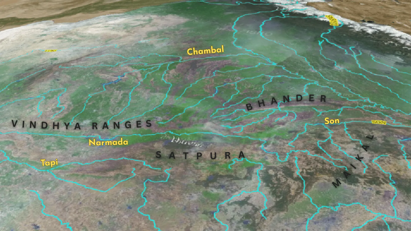
The Vindhya Range, a prominent mountain range in Madhya Pradesh, forms part of the Narmada valley and creates a steep slope along the northern edge of the Narmada-Son Trough. Extending for about 1,200 km from Jobat in Gujarat to Sasaram in Bihar, it runs almost parallel to the Narmada valley in an east-west direction. The elevation of the range generally varies between 300 to 650 meters, marking a natural boundary that separates regions of different heights.
Eastwards, the Vindhya Range continues as the Bharner and Kaimur hills, further enhancing its geographical importance. Several major rivers, including the Chambal, Betwa, and Ken, originate within 30 km of the Narmada, highlighting the range’s role in feeding central India’s river systems. This mountain system is not only a geographical divider but also an important landmark in shaping the terrain and ecology of central India.
Satpura Range
The Satpura Range, a major mountain range in Madhya Pradesh, means “series of seven mountains” (‘sat’ = seven, ‘pura’ = mountains). Running east to west, it lies south of the Narmada and Tapi rivers, parallel to the Vindhya Range. Satpura is famous for tourist spots like Pachmarhi, also called Satpura ki Rani. Dhupgarh (1,350 m) near Pachmarhi in the Mahadeo Hills is its highest peak, while Amarkantak (1,127 m) is another important peak.
Maikal Range
The Maikal Hills, also known as the Maikal Range, are a prominent mountain range located in central India, extending across parts of Madhya Pradesh and Chhattisgarh. They represent the eastern section of the larger Satpura Range. This range is characterized by flat-topped plateaus, referred to as ‘pats’, with elevations typically ranging between 600 and 900 meters. It also boasts a dense forest cover.
The Maikal Range holds significant hydrological importance, serving as a vital watershed area, according to Testbook. Several major rivers originate from these hills, including the Narmada, Son, and Mahanadi. The Narmada River, a major west-flowing river of the peninsular region, begins its journey from the Amarkantak Plateau, which is part of the Maikal Range. Other rivers flowing through or originating in the Maikal range or having tributaries flowing through it include the Johilla, Pandu, Kanhar, Rihand, Bijul, Gopad, and Banas.
Bhander Range
The Bhander Ranges, part of the Vindhya Range, form an important mountain range in Madhya Pradesh. These plateaus and hills connect the Deccan Plateau in the south with the Indo-Gangetic Plains and the Chota Nagpur Plateau to the north and east. 6The Bhander plateau averages 500 meters in elevation, sloping west to east, and is covered with Bhander Range forest dominated by teak and catechu trees. Rivers like Ken, Tons, and Son rise from the Vindhya Range, of which Bhander is a part. The range covers regions of Panna, Chhatarpur, and Datia, with nearby towns including Katni, Damoh, Maihar, and Hatta. The National Highway through Katni is the only major road crossing the plateau.7
The Vast Forest Area of Madhya Pradesh
Madhya Pradesh has the largest forest area among all Indian states. As per the India State of Forest Report (ISFR) 2023, the state’s forest cover is around 77,073 sq. km, which is about 25% of its geographical area. This includes very dense, moderately dense, and open forests, with the latter two forming most of the cover.
The forest area of Madhya Pradesh is diverse, consisting mainly of Tropical Dry Deciduous and Tropical Moist Deciduous forests. These forests support rich biodiversity and play a vital role in maintaining ecological balance.
Although the state recorded a decline of 612.41 sq. km in forest and tree cover between 2021 and 2023, it still holds the top position in India in terms of total forest cover by area.8
| National Park | Nearby District/Town |
| Bandhavgarh National Park | Umaria 🚆, Jabalpur 🚆✈️ |
| Kanha National Park | Mandla 🚆, Balaghat 🚆, Jabalpur 🚆✈️ |
| Panna National Park | Panna 🚆, Chhatarpur 🚆, Khajuraho 🚆✈️ |
| Pench National Park | Seoni 🚆, Chhindwara 🚆, Nagpur 🚆✈️ |
| Satpura National Park | Narmadapuram 🚆, Bhopal 🚆✈️, Pipariya 🚆 |
| Sanjay-Dubri National Park | Sidhi 🚆, Singrauli 🚆 |
| Madhav National Park | Shivpuri 🚆 |
| Van Vihar National Park | Bhopal 🚆✈️ |
| Ghughua Fossil Park | Jabalpur 🚆✈️, Mandla 🚆 |
| Dinosaur Fossils National Park | Dhar 🚆 |
| Kuno National Park | Sheopur 🚆, Shivpuri 🚆 |
| Omkareshwar National Park | Khandwa 🚆 |
Wildlife Sanctuaries in Madhya Pradesh
| Wildlife Sanctuary | Nearby District |
| Bori Wildlife Sanctuary | Narmadapuram 🚉 |
| Bagdara Wildlife Sanctuary | Singrauli 🚉, Sidhi 🚉 |
| Gandhi Sagar Wildlife Sanctuary | Mandsaur 🚉, Neemuch 🚉 |
| Ratapani Wildlife Sanctuary | Raisen 🚉, Bhopal 🚉✈️ |
| Chambal Wildlife Sanctuary | Morena 🚉, Sheopur 🚉 |
| Nauradehi Wildlife Sanctuary | Sagar 🚉, Damoh 🚉 |
| Orchha Wildlife Sanctuary | Orchha 🚉, Lalitpur 🚉 |
| Veerangana Durgavati Wildlife Sanctuary | Narsinghpur 🚉, Jabalpur 🚉✈️ |
| Gatigaon Wildlife Sanctuary | Gwalior 🚉✈️ |
| Ken Gharial Sanctuary | Panna 🚉, Chhatarpur 🚉 |
| Kheoni Wildlife Sanctuary | Dewas 🚉 |
| Pachmarhi Wildlife Sanctuary | Hoshangabad 🚉 |
| Panpatha Wildlife Sanctuary | Umaria 🚉, Katni 🚉 |
| Pench Wildlife Sanctuary | Seoni 🚉, Chhindwara 🚉 |
| Phen Wildlife Sanctuary | Mandla 🚉 |
| Ralamandal Wildlife Sanctuary | Indore 🚉✈️ |
| Sailana Wildlife Sanctuary | Ratlam 🚉 |
| Sardarpur Wildlife Sanctuary | Dhar 🚉 |
| Singhori Wildlife Sanctuary | Raisen 🚉 |
| Son Gharial Wildlife Sanctuary | Sidhi 🚉, Shahdol 🚉, Umaria 🚉 |
We have covered in another article the National parks and Wildlife sanctuaries in India where you can spot a Royal Bengal Tiger in the wild.
Rivers of Madhya Pradesh: Lifelines of the Region
Narmada and Tapi River System
The Narmada and Tapi river basins are vital for Indian agriculture, sustaining millions of farmers in Madhya Pradesh, Maharashtra, and Gujarat. The Narmada basin spans about 92,672 sq. km, with nearly 57% of its land under cultivation. Its rich black soil and abundant water support wheat, pulses, oilseeds, and cotton farming. Irrigation projects like the Sardar Sarovar Dam have transformed drought-prone areas, expanding agricultural productivity and ensuring water availability.910
The Tapi basin, covering 65,145 sq. km, has over 66% of land devoted to agriculture. It is especially known for crops like sugarcane, cotton, soybean, and wheat. The Ukai Dam and other irrigation systems provide water to nearly 4.5 million hectares, making it one of India’s largest cotton-producing zones. Fertile plains and reliable irrigation make the basin a cornerstone for regional food and cash crop production.11
Together, the Narmada and Tapi basins form lifelines for farmers, directly supporting more than 60% of the local population. They not only secure food supply but also drive economic growth through crop diversity and large-scale irrigation benefits.12 Their contribution highlights the importance of river basins in sustaining agriculture and livelihoods across central and western India.13
Chambal River
The Chambal River originates in the Janapav hills of Madhya Pradesh and flows north-northeast through Morena, Sheopur, and Gwalior. It creates deep ravines that shape the region’s landscape and plays a crucial role in irrigation, wildlife support, and soil conservation in northwestern Madhya Pradesh. 14
Son, Ken and Betwa Rivers
The Son River originates near Amarkantak in Anuppur district, Madhya Pradesh, and flows north-northwest through Shahdol before turning east. As a major southern tributary of the Ganga, it supports agriculture, groundwater recharge, and connects Madhya Pradesh’s interior to eastern India.15
The Betwa River rises near Bhopal and flows northeast through Raisen, Vidisha, and Orchha. It is vital for irrigation, drinking water, and carries historical importance as it passes ancient sites before merging with the Yamuna in Uttar Pradesh.16
The Ken River begins in Katni district and flows through Sagar, Damoh, and Panna. Known for its gorges and clear water, it sustains agriculture, supports biodiversity in Panna Tiger Reserve, and supplies drinking water to Bundelkhand’s semi-arid regions.17
How Geography Impacts Tourism in Madhya Pradesh?
If Uttarakhand, Himachal, and Kashmir are known for snow and Himalayan peaks, and Goa, Kerala, and Andamans for beaches, then Madhya Pradesh is for eco-tourism. Here, travelers immerse in forests and observe rich wildlife. With vast forest cover, excellent air and rail connectivity, it is among the most viable destinations for short trips.
Madhya Pradesh leads in tiger tourism and has now become home to cheetahs reintroduced in Kuno National Park, adding to its unique wildlife attractions.
For those who love jungle camping and adventure tourism, the state offers memorable experiences in the forests of Narmadapuram, Pachmarhi, Khajuraho, Orchha, Amarkantak, Bhedaghat, Bargi Dam, and many more scenic locations. These destinations make Madhya Pradesh a true hub for eco-tourism in India.
- Pench Tiger Trail
- Narmada Backwater Trek in Kherwada
- Panchmarhi, is the queen of hills as well queen of all trekking location, it hosts the most trekking locations, with a separate list:
- Sangam Trek
- Silver Fall Trek
- Duchess Fall Trek
- Vijay Prapat Trek
- Patharchata Pency Pool Trek
- Panchmarhi Hill Trek
- Chauragarh Trek
[Source: https://www.mptourism.com/trekking-adventures-in-madhya-pradesh.html]
Eco tourism in Patalkot near Chhindwara, for more details check this article.
Adventure Sports and Quality stay at the Backwaters of Gandhi Sagar Dam, more information over here.
Where to Stay? Exploring Madhya Pradesh on a Budget
This is the most important part of the blog. By now, you have explored all the amazing destinations and prepared your travel itinerary. If you are visiting Central India, Jabalpur is the best place to start. Located in the eastern part of Madhya Pradesh, the city is well connected to major tourist, eco, and adventure spots. With direct rail and flight connectivity from Delhi, Mumbai, Bangalore, and Hyderabad, Jabalpur serves as the perfect launch pad for travelers.
Adding to this convenience, Hotel Anand offers budget-friendly stays with 24-hour rooms starting at just ₹500. If you’re searching for a hotel in Jabalpur under 500, this is an ideal choice. The hotel is centrally located, just 1 km from Jabalpur Railway Station, ensuring easy access to all transport options. We welcome tourists, families, and adventure enthusiasts, providing them with a comfortable stay to prepare for their next destination.
Call now to book your room at Hotel Anand and make your Jabalpur trip more relaxed and affordable.
Citations:
- https://madhyapradesh.pscnotes.com/mppsc-mains-pyqs/mppsc-mains-2016-paper-i/where-is-the-bundelkhand-plateau-located-in-madhya-pradesh/ ↩︎
- https://www.baghelkhandtourism.com/about-baghelkhand.html ↩︎
- https://vajiramandravi.com/upsc-exam/malwa-plateau/ ↩︎
- https://en.wikipedia.org/wiki/Vindhya_Range ↩︎
- https://en.wikipedia.org/wiki/Nimar ↩︎
- https://en.wikipedia.org/wiki/Bhander_Plateau ↩︎
- https://www.britannica.com/place/Bhander-Plateau ↩︎
- https://www.pib.gov.in/PressReleasePage.aspx?PRID=1789635 ↩︎
- https://narmada.org/nvdp.dsrp/agr.htm ↩︎
- https://www.indiawris.gov.in/wiki/doku.php?id=narmada_basin ↩︎
- https://www.indiawris.gov.in/wiki/doku.php?id=tapi_basin ↩︎
- https://www.researchgate.net/publication/342487474_Narmada_basin_A_case_study ↩︎
- https://cwc.gov.in/sites/default/files/namada-basin-profile.pdf ↩︎
- https://vajiramandravi.com/current-affairs/chambal-river/ ↩︎
- https://mpholidays.com/subchild-pages/son-river/ ↩︎
- https://www.britannica.com/place/Betwa-River ↩︎
- https://bundelkhand.in/info/rivers-of-bundelkhand ↩︎